The Cairo Metro is the rapid transit system serving Greater Cairo in Egypt. It was the first full metro system in Africa and the first in the Middle East, opening in 1987 with Line 1 from Helwan to Ramses Square. As of 15 May 2024, the system has 3 operating lines, 84 stations, 5 transfer stations, and a total network length of 106.8 kilometres (66.4 miles). It is owned by the National Authority for Tunnels, uses standard gauge track, and remains a core part of public transport and city transport in Cairo. The metro usually runs from 05:00 to 01:00, with extended opening hours during Ramadan, and the network continues to grow through ongoing expansion plans.
| Key | Information |
|---|---|
| System | Cairo Metro |
| Location | Greater Cairo, Egypt |
| Opening | 1987 |
| Lines | 3 |
| Stations | 84 |
| Transfer stations | 5 |
| Total length | 106.8 kilometres (66.4 miles) |
| Owner | National Authority for Tunnels |
| Usual operating hours | 05:00 to 01:00 |
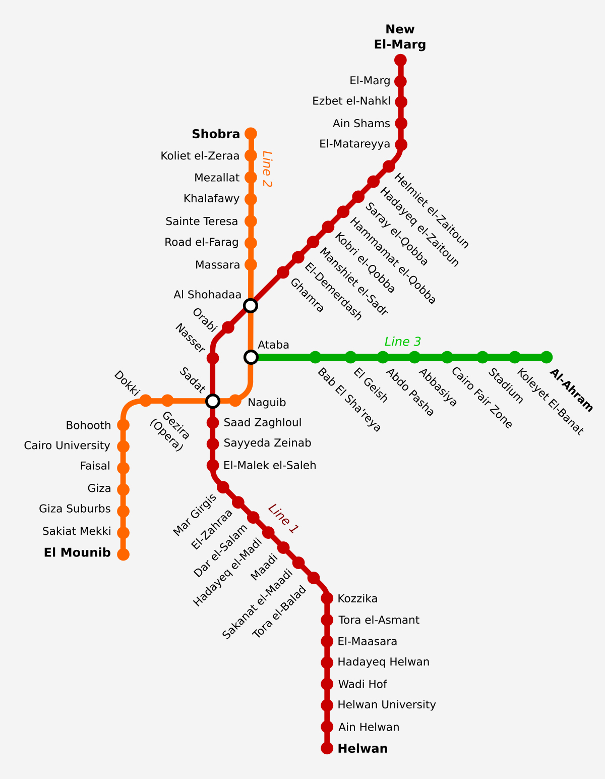
Cairo Metro Map
Map of Cairo Metro showing different lines and stations. Click on the map to enlarge it or download the Cairo Metro map in PDF format.
Lines and Stations
The Cairo Metro route plan currently includes three operational lines, numbered 1 to 3. As of 15 May 2024, the network covers 106.8 kilometres (66.4 miles) and includes 84 stations. If you are checking the stations map or looking for a quick stations list, these are the main line paths in the system.
Line 1
Line 1 runs from New Marg to Helwan. It is the oldest route in the network and includes major stations such as El-Marg, Al-Shohadaa, Sadat, Helwan University, and Helwan.
| Station | Details |
|---|---|
| New Marg | Line 1 northern terminus |
| El-Marg | Station on Line 1 |
| Al-Shohadaa | Key station on Line 1 |
| Sadat | Key station on Line 1 |
| Helwan University | Station on Line 1 |
| Helwan | Line 1 southern terminus |
Line 2
Line 2 connects Shubra Al Khaimah with El Monib. Important stations on this route include Al-Shohadaa, Sadat, Cairo University, Dokki, Opera, Shubra El-Kheima, and El-Mounib.
| Station | Details |
|---|---|
| Shubra Al Khaimah | Line 2 terminus |
| Shubra El-Kheima | Station name form used in source material |
| Al-Shohadaa | Key station on Line 2 |
| Sadat | Key station on Line 2 |
| Dokki | Station on Line 2 |
| Opera | Station on Line 2 |
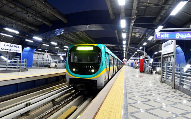
| Cairo University | Key station on Line 2 |
| El-Mounib | Line 2 terminus listed in source material |
| El Monib | Line 2 terminus listed in source material |
Line 3
Line 3 currently operates between Rod El Farag Corridor and Adly Mansour, and also between Cairo University and Adly Mansour. Stations mentioned in the source material include Attaba, Nasser, Kit Kat, Maspero, Al-Ahram, Heliopolis Square, El Nozha, and Adly Mansour.
| Station | Details |
|---|---|
| Rod El Farag Corridor | Line 3 branch terminus |
| Cairo University | Line 3 branch terminus |
| Attaba | Station on Line 3 |
| Nasser | Station on Line 3 |
| Kit Kat | Station on Line 3 |
| Maspero | Station on Line 3 |
| Al-Ahram | Station on Line 3 |
| Heliopolis Square | Station on Line 3 |
| El Nozha | Station on Line 3 |
| Adly Mansour | Line 3 terminus and interchange point |
Some station names appear in slightly different forms across the source material, but the operating network stays organized around these three lines.
| Station | Details |
|---|---|
| Line 1 | New Marg – Helwan |
| Line 2 | Shubra Al Khaimah – El Monib |
| Line 3 | Rod El Farag Corridor / Cairo University – Adly Mansour |
Operating Hours
The Cairo Metro operating hours are generally 5:00 AM to 1:00 AM every day, with later closing time during Ramadan on some schedules, when trains may run until 2:00 AM. These opening times leave the remaining hours for maintenance. Exact timings, working hours, and schedule today can vary by line and by service announcements, so travelers often check the latest train schedule before setting out.
The published timetable below shows the main starting time and last train information from the source material.
| Service detail | Timings |
|---|---|
| General operating hours | Daily 5:00 AM to 1:00 AM |
| Ramadan extended hours | Up to 2:00 AM on some schedules |
| Line 1 first train | 5:15 AM |
| Line 1 last train | 12:15 AM from both Helwan and New El-Marg |
| Line 2 first train | 5:15 AM |
| Line 2 last train | 12:30 AM from Shubra El-Kheima and 12:40 AM from El-Monib |
| Line 3 first train | 5:15 AM between Adly Mansour and Cairo University; 5:20 AM from Adly Mansour and 5:15 AM from Rod El-Farag Corridor on the Adly Mansour-Rod El-Farag service |
| Line 3 last train | 12:06 AM from Adly Mansour and 12:23 AM from Cairo University; 12:02 AM from Adly Mansour and 12:26 AM from Rod El-Farag Corridor on the other service |
| Late transfer at Anwar El-Sadat | 1:00 AM |
| Late transfer at Gamal Abdel Nasser and Attaba | 12:30 AM |
| Late transfer at Cairo University | 12:15 AM |
Frequency is usually better during peak periods. One published update noted headways of about 4.5 minutes before iftar during Ramadan. If you need timings today, the last train and transfer times matter most, especially late in the evening.
Prices, tickets and discounts
Cairo Metro uses a distance-based fare system, so the fare, ticket price, and overall cost depend on how many stops you travel. Tickets, pass options, and card products are available for regular riders, elderly passengers, students, and people with special needs. There is no fare calculator in the source material, but the ticket and pass tables below show the listed price levels.
Cash wallet
The metro offers a contactless cash wallet card for single rides. This card costs 80 EGP (about $1.69), is not named, can be used by anyone, and is sold at all metro stations on the three lines. It can be loaded with 40 to 200 EGP (about $0.85 to $4.23) and recharged multiple times if undamaged.
A separate wallet card for tap in and tap out is listed at 65 EGP (about $1.37).
Single-use tickets
| Ticket type | Validity | Price |
|---|---|---|
| 9 stations | 1 trip | 8 EGP (about $0.17) |
| 16 stations | 1 trip | 10 EGP (about $0.21) |
| 23 stations | 1 trip | 15 EGP (about $0.32) |
| More than 23 stations | 1 trip | 20 EGP (about $0.42) |
| 9 stations – Elderly | 1 trip | 4 EGP (about $0.08) |
| 16 stations – Elderly | 1 trip | 5 EGP (about $0.11) |
| 23 stations – Elderly | 1 trip | 8 EGP (about $0.17) |
| More than 23 stations – Elderly | 1 trip | 10 EGP (about $0.21) |
| Special Needs ticket | 1 trip | 5 EGP (about $0.11) |
| Capital Train – 3 stations | 1 trip on Capital Train | 10 EGP (about $0.21) |
| Capital Train – 7 stations | 1 trip on Capital Train | 15 EGP (about $0.32) |
| Capital Train – more than 7 stations | 1 trip on Capital Train | 20 EGP (about $0.42) |
| Children under 4 years old | Free travel | 0 EGP ($0.00) |
Monthly subscriptions
| Pass type | Validity | Price |
|---|---|---|
| Monthly pass – Public | 60 trips | Starting at 310 EGP (about $6.55) |
| Monthly pass – Elderly | 60 trips | Starting at 220 EGP (about $4.65) |
| Capital Train – Monthly 3 stations | Unlimited trips | 300 EGP (about $6.34) |
| Capital Train – Monthly 7 stations | Unlimited trips | 500 EGP (about $10.56) |
| Capital Train – Monthly more than 7 stations | Unlimited trips | 600 EGP (about $12.68) |
Quarterly subscriptions
| Pass type | Validity | Price |
|---|---|---|
| Quarterly pass – Public | 180 trips | Starting at 835 EGP (about $17.64) |
| Quarterly pass – Elderly (60-70 years old) | 180 trips | Starting at 660 EGP (about $13.94) |
| Elderly (over 70 years old) | 180 trips | 0 EGP ($0.00) |
| Quarterly pass – Special Needs | 180 trips | Starting at 150 EGP (about $3.17) |
| Quarterly pass – Students | 180 trips | Starting at 150 EGP (about $3.17) |
Annual tickets
| Pass type | Validity | Price |
|---|---|---|
| 2 lines Annual pass | 730 trips | 4235 EGP (about $89.43) |
| 3 lines Annual pass | 730 trips | 5335 EGP (about $112.66) |
Subscription offices
Quarterly subscription offices are listed across all three lines, while annual pass offices are available at selected stations.
- Line 1 quarterly offices: Helwan, Ain Helwan, Helwan University, Maadi, Dar el-Salaam, El-Zahra, Al-Shohadaa, Hadayeq El-Zaitoun, Ain Shams, Ezbet El Nakhl, Old El-Marg, New El-Marg.
- Line 2 quarterly offices: Kolleyyet El-Zeraa, Mezallat, Rod El-Farag, Masarra, Al-Shohadaa, Attaba, Dokki, University of Cairo, Giza, El-Mounib.
- Line 3 quarterly offices: Attaba, El Abassiya, Heliopolis, Adly Mansour.
- Line 1 annual offices: Helwan, Maadi, Ain Shams.
- Line 2 annual offices: Kolleyyet El-Zeraa, Rod El-Farag, Al-Shohadaa, Attaba, Cairo University.
- Line 3 annual offices: Heliopolis, Adly Mansour.
Connections to Other Systems
The Cairo Metro is closely tied to the wider transport network in Greater Cairo. As part of daily transportation in Cairo, the metro links with other rail services and supports connections with bus stations, main railway stations, and future projects.
Current metro interchanges include Al Shohadaa and Sadat, where Line 1 meets Line 2. Line 3 connects with Line 1 at Gamal Abdel Naser and with Line 2 at Ataba and Cairo University. Line 3 also links to Cairo Light Rail Transit at Adly Mansour.
Planned links mentioned in the source material include future interchanges for Line 4 with Line 1 at El-Malek El-Saleh and with Line 2 at Giza Railway Station. Longer-term plans for Lines 5 and 6 also include more interchange points with the existing metro system, as well as links to the airport and bus stations.
In the broader local transport picture, the source material also mentions the former Metro Heliopolis tramway network, which was separate from the metro and was closed in stages until the final section was abandoned in 2019. Monorail projects are also part of the wider city transport system: the East Nile Monorail is described as linking East Cairo to the New Administrative City and is associated with Cairo Stadium station on Line 3, while the West Nile Monorail is planned between Giza and 6th of October City.
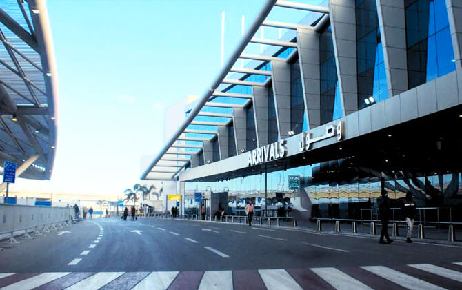
Airport Connections
Cairo Metro does not yet have a direct path train or metro rail link to Cairo International Airport. Still, Line 3 already reaches the Heliopolis area and the airport corridor, and the available material says it is planned to continue to the airport through Line 3 Phase 4C.
This proposed airport extension would run about 7.0 kilometres (4.3 miles) and include five tunnel stations. It is described as passing through Al-Hegaz Square, the Military Academy area, and Sheraton District before reaching Cairo International Airport. No firm completion date is given in the main source material, although one note says the airport connection starts operating in 2025.
For now, airport access relies on bus, taxi, or car. The material mentions CTA city bus services from Terminal 1, including bus line 111 to Shoubra and bus line 381 toward Imbaba, both stopping at Midan Ramses near Ramses Railway Station. From Terminals T2 and T3, travelers can reach the Terminal 1 bus station by the APM Automated People Mover and shuttle bus.
Road travel time from Cairo Airport to central Cairo is about 30 minutes, though it can stretch to around an hour in peak traffic. A bus ticket is listed at 10.00 EGP (about $0.21).
- Cairo International Airport is planned to be linked by Line 3, but it is not served directly yet.
- The proposed airport rail extension is Line 3 Phase 4C.
- Current airport transport options are bus, taxi, and car.
- Terminal 1 is the main point mentioned for CTA city buses.
Useful Information
The Cairo Metro is a major part of public transport in the Egyptian capital and one of the busiest pieces of local transport in the region. The network has 3 operational lines, 84 stations, 5 transfer stations, and a total length of 106.8 kilometres (66.4 miles). Usual opening hours are 05:00 to 01:00, with later running time during Ramadan until 02:00 on some schedules.
Women have reserved middle cars on each train. Since 1989, the 4th and 5th cars have been reserved for women, with the 5th car becoming mixed-use after 21:00. Women may also use any other car if they prefer.
The network includes important transfer points such as Al Shohadaa, Sadat, and Nasser, helping passengers move across the city with less dependence on road traffic. For many people, it is the simplest way to get around Cairo safely and efficiently.
The source material does not provide details on station parking, parking charges, or parking charges per day.
History
Cairo’s metro history is closely tied to the city’s need for higher-capacity transport. Greater Cairo was already the largest and most densely populated megacity in Africa and the Middle East, and by 1987 it had about 10 million residents, plus roughly 2 million daily commuters. Before the metro, public transport capacity was around 20,000 passengers per hour; after the system was built, that figure rose to 60,000.
Background
The idea of building a metro in Cairo first appeared in the 1930s, when engineer Saiyed Abdel Wahed of the Egyptian Railway Authority proposed it. Nothing moved ahead then, but after the Egyptian Revolution of 1952, interest returned. In 1954, French experts prepared a report on the future of transport in Egypt.
That report suggested two metro lines: a 12-kilometre (7.5-mile) line between Bab al-Louq and Ismailia, and a 5-kilometre (3.1-mile) line between Boulaq and Abou al-Ela Castle. The experts also recommended creating one company to manage all transport systems.
Proposed plans
More studies followed from Soviet experts in 1956, Japanese experts in 1960, and French experts in 1962. These backed the idea of a multi-line metro system. Their proposals included a 5-kilometre (3.1-mile) line between Helwan and El-Marg, a 9.5-kilometre (5.9-mile) line from Sayyidah Zaynab Mosque to Shobra, an 11.5-kilometre (7.1-mile) line from Giza to Abbaseya, and a 6.7-kilometre (4.2-mile) line from Al Awqaf to the Castle.
In 1964, British experts recommended a line from Bab El Louk to Shubra. In 1966, Japanese experts proposed one line between Helwan and El Marg and another through Mohandiseen, Heliopolis, and 26 of July Street, for a total of 26 kilometres (16.2 miles).
In 1969, the government approved a study of Cairo’s transport capacity. The Ministry of Transport launched an international tender, and the French company SOFRETU won it in September 1970. Completed in 1973, the study looked at population growth and transport demand for 1980, 1985, and 1990, and concluded that Greater Cairo needed three metro lines.
The first line would use existing railways and connect Helwan with Bab El Louk and Al Laymoun Bridge with El Marg, for a total length of 43 kilometres (26.7 miles). The second would run 13.5 kilometres (8.4 miles) from Shubra El-Kheima to Bulaq through Ramses Street and Tahrir Square. The third would be 10 kilometres (6.2 miles) long, from El Darasa to Imbaba. Line 1 was prioritized because it could cut transport demand while reusing existing rail infrastructure. Detailed design work ran from 1975 to 1981, and the Egyptian-French company Entra Nevra Arabco won the construction tender.
Construction works
Construction of Line 1 began in 1982 after the French government agreed to provide the required loan. The first section opened on 27 September 1987, and the line was completed in 1989. It linked Helwan with El Marg and had 34 stations across 42.5 kilometres (26.4 miles), including 4.7 kilometres (2.9 miles) underground. In 1999, New El Marg station was added at the northern end, extending the line to 44 kilometres (27.3 miles). Helwan University station was also built between Wadi Houf and Ain Helwan.
The network grew further in the mid-1990s with Line 2, built from Shoubra El Kheima to Cairo University and later extended to Giza. This line includes the first tunnel under the Nile. Construction was completed in October 2000, and the line was later extended to El Mounib.
Line 3 came later to increase capacity. Its first section opened in 2012, and the line has continued to expand in phases. A 1999 transport study also recommended a six-line system built around existing Lines 1, 2, and 3, plus future Lines 4, 5, and 6.
Future Extensions
Cairo Metro expansion is still moving forward, with several planned and studied projects designed to improve transport connections across Greater Cairo.
Line 4
Line 4 is the main future project. Its first phase is under construction and is planned to run 19 kilometres (11.8 miles) from Hadayek Al-Ashgar to Al-Fustat, with 17 stations. It will connect with Line 1 at El-Malek El-Saleh and with Line 2 at Giza, while also serving dense districts and major destinations such as 6th of October City and the Grand Egyptian Museum.
Further phases are also under study. One proposal would extend Line 4 through Nasr City toward New Cairo, with an interchange with Line 6 and connections to the East Nile Monorail. Another branch would go west toward Hosary Square in 6th of October City and connect with the West Nile Monorail. A later phase is planned to reach Capital Airport Station and link with the Light Rail Transit.
Line 3 extension to Cairo International Airport
Line 3 has a proposed future extension from Heliopolis to Cairo International Airport. The plan would add about 7 kilometres (4.3 miles) and five tunnel stations, passing through Al-Hegaz Square and the Military Academy area before reaching Sheraton District and the airport.
Line 2 extension to Qalyub
There are also plans to extend Line 2 north from Shubra Al-Kheima to Qalyub. This extension would add 7 kilometres (4.3 miles) and is intended to ease growing traffic at the northern entrances to Cairo.
Long-term network plans
A wider transport study for Greater Cairo recommended a six-line metro network. Alongside the existing three lines, it includes future Lines 4, 5, and 6 to improve access to densely populated areas and create better interchange with railway stations, airports, and bus terminals.
Under these long-term plans, Line 5 would form a half-circular route in northern Cairo, while Line 6 would run north to south between Shubra, Maadi, and Tura. Timelines depend on funding and implementation progress.
Nearby Attractions
Cairo Metro makes it much easier to reach some of the city’s best-known sights, especially from central stations such as Sadat, Opera, and Mar Girgis. For visitors, it is a practical way to mix sightseeing with everyday transport without getting stuck in road traffic.
Near Sadat Station, Tahrir Square and the Egyptian Museum are major highlights. Around Mar Girgis, the metro provides access to Coptic Cairo and the Hanging Church. Other places mentioned in the source material include Al-Azhar Mosque, Islamic Cairo, the Mosque of Muhammad Ali, Al-Azhar Park, and Nile River viewpoints.
Opera Station is useful for reaching the Cairo Opera House area, while Mohammad Naguib Station works well as an access point for downtown Cairo. If you are planning tours, the source material also mentions local operators such as Memphis Tours, Rimo Tours, Pyramids Land Private Tours, and Travel Door Tours.
- Sadat Station: close to Tahrir Square and the Egyptian Museum
- Opera Station: convenient for the Cairo Opera House area
- Mar Girgis Station: useful for Coptic Cairo and nearby churches
- Mohammad Naguib Station: a good access point for downtown Cairo
- Al-Azhar Park area: a popular place for views and walking